Measuring the Success of the MBTA Communities Law
The Lessons of Marblehead, Newton, and Belmont
If you follow the ongoing and often heated debate over housing policy in Massachusetts, you likely saw the viral moment at a recent Marblehead town meeting, when a resident—dressed like a stand-in from a John Fetterman biopic—spoke during public comment. The controversy centered on Marblehead’s compliance with Section 3A of Chapter 40A of the Massachusetts General Laws—commonly known as the Massachusetts Bay Transit Authority (MBTA) Communities Law, or simply “3A.” The town had satisfied its obligation to zone for additional multifamily housing by upzoning an existing private golf course that is unlikely to be redeveloped anytime soon. Once the clip spread online, YIMBYs on social media condemned the move as cynical gamesmanship, while NIMBYs seized on it as evidence that both the scope and implementation of the law are fundamentally flawed.
But the lesson of Marblehead is almost the opposite. The MBTA Communities Law, as conceived and implemented by the Commonwealth’s Executive Office of Housing and Livable Communities (EOHLC), works precisely because it gives municipalities with vastly different physical characteristics, real estate markets, and political temperaments a viable path toward accommodating future multifamily housing—even when the process of getting there is contentious.
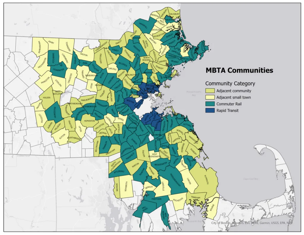
The framework for compliance was relatively straightforward. First, each municipality covered by the law was assigned a target number of multifamily housing units that its new zoning had to accommodate, based in part on the size of its existing housing stock. Second, communities were required to use a standardized formula to test alternative zoning scenarios and demonstrate compliance. The law also distinguished between municipalities directly served by transit and “MBTA-adjacent” communities like Marblehead, Peabody, and Dover, which operated under less restrictive siting rules. That flexibility helps explain why Marblehead could comply by rezoning a golf course on the edge of town.
Communities with direct transit or commuter rail service faced more stringent requirements. At least 50 percent of the rezoned land had to fall within a half mile of a transit station; no rezoned district could be smaller than five acres; and any new district had to permit a minimum density of 15 units per acre—somewhat more than half the density of a typical triple-decker neighborhood in Boston or Somerville. The minimum district-size requirement was intended to prevent municipalities from complying through isolated spot rezonings of underperforming industrial or commercial parcels far removed from transit access. At the same time, large landholdings such as golf courses could still satisfy the acreage threshold, as Marblehead demonstrated.
In practice, these requirements produced constructive outcomes in places like Newton and Belmont, where both neighborhood preservationists and advocates for denser housing had meaningful stakes in the process. The regulations proved flexible enough to support compromises that could ultimately secure approval from planning boards and municipal councils.
In Newton, which is exceptionally well served by both Green Line and commuter rail stations, the law allowed the city to distribute new zoning districts across nine village centers where historic development patterns had already established densities distinct from the surrounding single-family neighborhoods. The dimensional standards adopted to achieve the city’s required housing capacity were calibrated to produce buildings only modestly taller than the existing prewar fabric surrounding the stations. Before-and-after visualizations—presented from both aerial and pedestrian perspectives—helped demonstrate the compatibility of future development with the existing urban context. Because Newton could distribute growth across multiple village centers, planners did not need to rely on remote or disconnected parcels to achieve compliance.


Belmont, similarly rich in transit access, approached compliance in much the same way. Roughly 15 to 20 percent of the town lies within a half mile of its two commuter rail stations, reducing any incentive to include peripheral sites in its rezoning strategy. Most of the rezoned parcels were concentrated around the stations themselves, where auto-oriented suburban commercial uses had gradually eroded what were once more coherent walkable mixed-use districts. Exceptions included a Belmont Housing Authority property located roughly midway between the two stations, as well as a large industrial parcel along the rail corridor near the Cambridge border but outside the prescribed half-mile radius. Both sites satisfied the law’s five-acre minimum requirement.
In both Newton and Belmont, the EOHLC regulations provided a workable framework for tailored local solutions. The law established minimum housing capacity targets and accounting rules, but left considerable room for municipalities to determine how those targets would be met. As a result, successful implementation depended on extensive community engagement and sustained public debate. Consensus became possible only when the urban design implications of different zoning approaches were made legible to residents.
Not every municipality undertook a process as comprehensive as those in Newton and Belmont. Some communities minimized controversy by simply converting existing discretionary zoning standards into as-of-right districts, thereby limiting public scrutiny of what future development might actually look like. Others concentrated their new zoning capacity within existing Chapter 40B developments—projects already shaped by earlier state efforts to override local zoning restrictions in order to promote affordable housing production. While these strategies may have eased the path to compliance, they also risk producing built outcomes that generate backlash, particularly in municipalities with strong real estate markets where redevelopment pressures are immediate and substantial.
The broader achievement of the MBTA Communities Law may be that it elevated zoning itself into mainstream civic discourse across Massachusetts. In many municipalities, the underlying zoning framework has remained largely unchanged since the 1970s, if not earlier. The law also forced a broader recognition that zoning authority ultimately derives from the state, rather than existing solely as a matter of local control. Attorney General rulings in cases where municipalities resisted compliance have reinforced that principle and reasserted the Commonwealth’s authority over local land-use regulation.
My perspective on the relative success of the MBTA Communities Law is rooted in direct experience. My firm, Utile, was one of several on-call consulting firms retained by EOHLC to assist municipalities in complying with 3A. Under that program, Utile worked with eight municipalities. Separately, the firm was engaged directly by Newton, Belmont, and Watertown to lead broader planning and rezoning initiatives in which 3A compliance was one important component.
For my colleagues and me, working simultaneously across eleven communities—each with distinct constraints, politics, and urban forms—deepened our appreciation for the degree to which zoning shapes not only the built environment, but also the social and civic character of communities.