Resisting Representation: The Informal Geographies of Rio de Janeiro
Until recently, obtaining maps and aerial photographs of Rio de Janeiro was not as easy as logging on to Google Earth. Now, from a computer anywhere in the world, one can spin a virtual globe, descend on a target, and hover over a pixilated field that eventually comes into focus as a city. This image renews itself in response to one’s commands, making it seem that few boundaries exist between the user and the abstract, flat clusters of houses, roads, buildings, airports, factories, and parks that form a city.
Invisible Cities
Obtaining maps and photographs of Rio de Janeiro—not ones drawn for visitors or even residents but ones for “experts” (technicians, planners, policemen, or the military)—once required bureaucratic privileges. This overview of the city’s spatial relationships, proximities, and distances, its areas of density and habitation, was guarded information. One reason is that the seemingly smooth and continuous space of endless drift on Google Earth is, on the ground, a battleground of isolated urban realities—a city less continuous, an aggregate of isolated political, economic, and social zones. The spatial logic of Rio de Janeiro reveals, to those able to read it as such, a process of what economists call uneven, incomplete, or partial development, which translates into the direct proximity of urban areas of extreme social differences.
Brazil is known for having naked extremes of wealth and poverty. This has not changed significantly in centuries of political upheavals that have included slavery, colonialism, empire, nationhood, modernization, dictatorship, and democracy. One of the most enduring images of how this affects Brazil’s cities is the favela. Favelas are Brazil’s urban informal settlements, which have become familiar, even iconic images of informal urbanity itself. However, even with their notoriety, representations of favelas are often incomplete or misleading. While the “culture” of the favela, usually reduced to samba music and dance, has historically been represented in the broader Brazilian culture, detailed information about favelas—how many there are, where they lie, how big they are, what their population is—was missing or suppressed.
Representations of favelas on maps of the city vary. Sometimes these dense urban neighborhoods are simply not included, and in their place are green areas that look like parks. If they are included on maps, they are usually coded in an uncertain or less committed strategy of representation. With the advent of aerial photography and the involvement of the government in favela upgrading programs, maps began to be produced for both planners and police. Archives and statistics on favelas have been assembled, but are filed separately, in a grey zone between official urban data and the realm of what can’t be represented or understood. Maps are produced based on government aerial photographs, not information gathered on the ground. As such, they are no more than traces of photographs. If one manages, as I did, to obtain access to the maps in the city planning department, one finds that these documents are filed separately from the city’s official plans, which do not show the buildings and streets of the city’s favelas. Rio has a progressive plan for upgrading favelas, but its geographic representations have not caught up.
When it comes to favelas, which by definition evade or exceed administrative or bureaucratic oversight, both the efficacy and the politics of conventional mapping (and of statistics and demographics) must be questioned. Statistics, etymologically a “science of the state,” have historically been an instrument of power. The indeterminacy of data on informality makes it particularly vulnerable to fabrication and manipulation. Census taking in favelas provides a notorious example. Population estimates for individual favelas vary widely, with differences between what the city declares the population to be and what the citizens themselves claim—usually a larger number that would give them a greater opportunity for political agency. The favela of Maré, for example, has even set up its own information-gathering center, which takes unofficial but probably more accurate census data of the neighborhood. Using this information, those in the center have argued that the neighborhood should be eligible for greater political representation and state funding.
It is unclear what the political effects of greater access to spatial information like that collected by Google Earth will be. Earlier this year, before Rio’s military police entered favelas with tanks and automatic weapons, occupying them for weeks and effectively turning daily life into war, they consulted Google maps to plan their operations. Spatial information can also be a source of political agency: recently satellite photos were used by human rights groups to corroborate eyewitness accounts of human rights abuses on the border between Thailand and Burma.
It is notoriously difficult to assess the population of an informal area, but it is equally difficult to determine what a favela is. Who decides, and how, that an area is a favela are loaded questions. Favelas are defined as much culturally and aesthetically as they are legally or statistically. Officially, authorities and planners in Rio de Janeiro use the definition “an abnormal agglomeration,” established in a 1950 census, which includes, in addition to the criterion of size, the illegal settlement of land and a lack of public facilities (transportation, water, sewage, maintenance, and municipal trash collection).1 Following these criteria, a map of Rio de Janeiro can be drawn showing its favelas, and this map will resemble a sea filled with islands large and small, a city with many smaller cities and overlapping sovereignties. This map could render the favelas not as blind spots in the psychological and epistemic charting of the city but as places of spatial and urban consequence. But it would nevertheless divide urban space along a hard line: favela / not favela (or morro/asfalto—hill /asphalt—as it is locally called). The city appears as continuous and connected, while the favelas appear as isolated not only from the city but also from one another. While favelas are often compared to the ghettos of Jews in Europe or of African Americans in postwar North American cities, how does the concept apply to a city in which there are almost 700 favelas? Can there be 700 ghettos?
Informal Geography: A City of Islands and Flows
Rio de Janeiro is a city with a population of just over six million in its central urban areas, of which, according to officials, an estimated 20% are residents of favelas. These favelas vary enormously in size and character. These urban islands, like those of the earth’s waters, have formed according to several genealogies and geologies. Some, like continental islands, share a history and underlying structure with those around them, as if they have collectively broken off from a land mass. Others, like volcanic islands, seem to develop independently and suddenly from more isolated and turbulent forces. Still other favelas, like coral atolls, build slowly on an underlying urban structure. These metaphors show how favelas differ in their relationship to their surroundings—their seemingly insular status belies the fact that submerged structures tie them to the city.
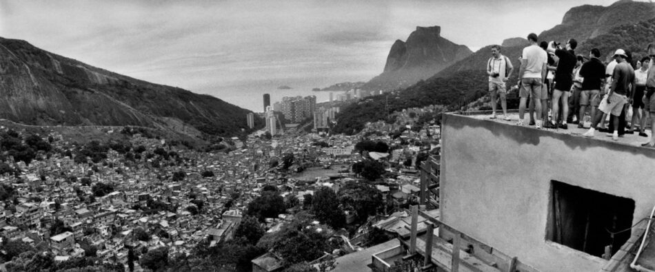
Rio has an unusual amount of green. Its topography of sudden protrusions of granite near the coast and substantial mountain ranges across the larger area has led to an atypical development of the city, the nucleus of which can be seen as a series of interconnected valleys among these massive peaks. When successive tunnels connected these parts of the city, it quickly expanded into outlying areas, which today remain formally and historically fragmented. It was these vertical interruptions that in the late 19th century became sites for the city’s first favelas, built on land deemed unsafe or inappropriate for construction. Thus a topographical split came to define the social landscape of the city, creating a condition in which many favelas are extremely close to neighboring areas—which may be the wealthiest residential zones—yet vertically isolated. This particular circumstance is not typical, however; many favelas also stretch over flat expanses of land far from the center. What a map showing favelas reveals is a collection of spaces that can range from a few hundred square meters to a few square kilometers, from 1,000 inhabitants to 100,000. In fact, few generalizations can be made about favelas’ size, typology or shape, income levels, age, and qualities as communities. The organizational cell of the favela is the self-built single-family unit that has the ability to form both very small and very large communities, to be repeated ad infinitum in what seems like monotonous replication but is actually a relentless singularity—no two houses are the same.
While no manifesto or charter determines how Rio is organized today, one can, in the tradition of the retroactive manifesto, read in the city a certain will, a design that has emerged out of its political processes. This fractured city has enclaves surrounded by walls and gates, entire streets that are closed off, and apartment buildings surrounded with security guards and cameras. It has more porous sectors of restaurants, shops, and bars that form affluent subcities, like the Zona Sul or Barra de Tijuca, as well as larger enclaves of enormous, air-conditioned shopping malls. The favelas, spread over the entire city, are recognizable by their irregular, unfinished buildings with exposed concrete columns and red bricks, their horizontality, high density, and rarely-higher-than-three-story buildings, and by the boundaries that surround them—vertiginous ascents, factories, canals, railroads, highways. The city’s borders are established aesthetically and typologically. And through force. Who guards these borders? How stable are they?
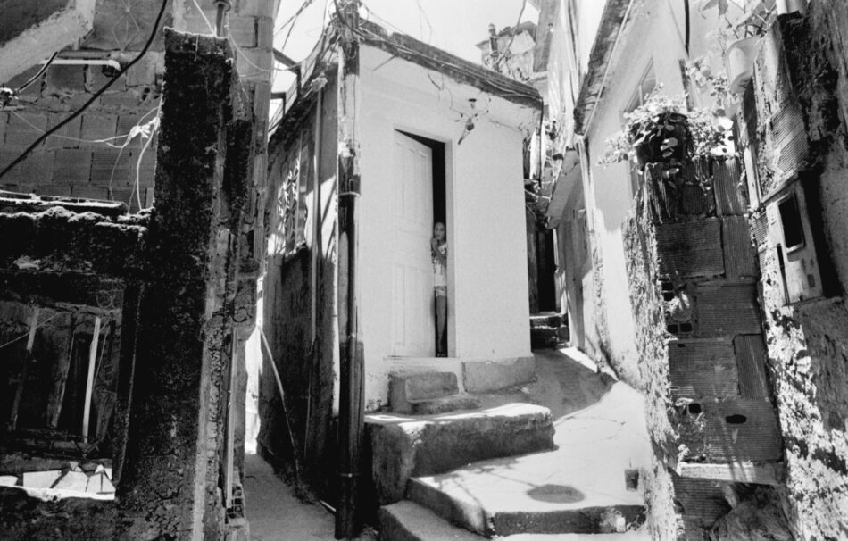
Providência, 100 years old, is usually considered Rio’s first favela. It is one of many hills near the city’s port that for centuries served as natural fortifications against seaborne invaders. From the beginning, the militaristic quality of the favela as a citadel was established by its topography. This topography characterizes the dual nature of the colony-like favela: it is a place of both confinement and resistance. For the government, it served as a prison-like space with clearly defined borders that contained unassimilable populations; for its residents, the borders are used to defend a territory long under constant threat of eviction, invasion, and exploitation. By the 1980s, this border turned into the front for a deadlier territorial conflict—that of the drug mafias that came to control the favelas and that are now engaged in private wars with elite military police.
As they developed on hilltops, the favelas became small cities, separated by their location, their poverty, their rural culture, and the race of their inhabitants. Even when favelas spread beyond the hills of downtown to inhabit flat and wetlands on small and large sites, they remained islands. Their outer edges were maintained by the cultural construct of their being places of disease and poverty, dangerous and chaotic zones that could not comfortably be considered part of the city. But the real margins and marginality, as anthropologist Janice Perlman has pointed out, were produced by the perpetual exploitation and containment of the “favelados.”2 Like the citizen of a country, the favelados are identified with where they reside. Sensationalist evening news programs show police invasions of favelas and the capture and arrest of suspects in the city who are identified as “marginais” (inhabitants of the margins). The geography of marginality is identified with the people themselves, even if the place they inhabit is at the core of the city.
Rio is divided according to a constantly emerging series of fissures that form its boundaries and barriers. Like a piece of origami paper that begins as a square but contains the possibilities for infinite proximities depending on where its folds are placed, the levels of difference and exclusion in Rio can be read in many ways, with unique yet inconclusive results every time.
One standard model is to read urban informality through the construct of a center and a periphery. In the radial pattern that many European cities historically followed, the city was surrounded by a wall, the barrier that determined who could enter, who was a burgher and who was not, what was city and what was country. At night the gates of the citadel were closed. But there were those left outside who began to build houses against those walls and clustered around the roads that led to the gates. When the land within the walls became inadequate to house the populations that descended upon the city, when the population outside became too large and too difficult to manage, a new wall was built to bring them under the city’s jurisdiction. This is the model of the faubourg (from the Old French fors, outside, and borc, town).3
If one imagines this same topological operation, but this time in a city with millions of citizens and no city wall, but instead smaller walls and enclaves, whether physical or electronic, what happens? In Rio this metaphorical city wall exists, but imploded and in different guises. The favela can be seen as a faubourg. It grows on top of the houses of the city,4 under its highways, in its hills, in isolated clusters along canals, in great strips along its rail lines. It also fills the city’s periphery around factories and in fallow agricultural fields. It goes into the water, in houses built on stilts that protrude over lagoons when there is no more space on land, or in swamps that are filled in with rubble that become the foundation for a new neighborhood. It is difficult to speak of a suburb when the suburb is everywhere.5
How do these favela islands form? Unlike the planned development of a city or suburb, in which infrastructures—roads, pipes, electrical lines—create a grid for houses and people to fill, the favela develops in reverse. The infrastructures do not officially come until much later, when the favela is urbanized and partially absorbed by the city. First the people come and build their houses; then roads evolve; electricity and water are pirated in. The infrastructure develops with the houses, one connection at a time. A community forms. Each favela, however small, gives itself a name: Kinder Ovo (named after the chocolate, Kinder Ei), Salsa y Merenge (a telenovela), Raio do Sol (ray of sun), Babilônia, Shangri-lá, Formiga (anthill), Telégrafos (where Brazil’s first telegraph network started). The favela begins to operate like a small town or city, with a local community association that takes on functions that would otherwise be those of the government: mail distribution, cable TV, land deeds, political representation, arbitration, security, public works, etc.
How these “towns” develop can be seen in a study of two neighborhoods, Providência and Rocinha, which differ in scale and history but share significant qualities such as easy visibility and proximity to the city center. The location of these favelas next to affluent and busy areas makes them particularly relevant examples of the island effect of favelas as heterogeneous zones within the urban continuum. What is also notable is the strong identity of these favelas as communities and places with histories and qualities distinct from those of the rest of the city. But they are still regarded as alien presences and suffer from the violence and stigma of exclusion and invisibility.
Rocinha—The Favela as City
Rocinha is perhaps the most famous and most urbanized of Rio’s favelas. Situated between the beaches of Ipanema and Leblon, the upscale neighborhood of Gavea, and the gated communities and luxury residences of Barra da Tijuca, Rocinha clearly illustrates a shocking contrast of formal and informal neighborhoods. It also benefits from this proximity by receiving media attention, jobs, and improvements. Rocinha was one of the first favelas in Rio to be considered a legitimate neighborhood by the city government (in 1986) and later an administrative region (in 1993).6 Today it is composed of fourteen distinct subneighborhoods; when one walks through the favela one sees how these differ dramatically in density, the width of streets, the quality and scale of the housing, the availability of infrastructural services, and the general quality of life.7 As with many favelas, the less accessible the houses— farther from the main road or on a steep incline—the lower their material quality. The considerable difficulty of commuting and carrying items to houses high on a hill makes these areas less desirable. Thus, one can still find wooden houses higher up, while the buildings in the main commercial area are indistinguishable from those in many “formal” neighborhoods. Rocinha is also one of the most populous favelas, though the estimates of its population vary immensely, from 60,000 residents to 150,000 residents.8 With its access to jobs and prosperous parts of the city, as well as what may possibly be the most attractive views in Rio, Rocinha’s real estate market is strong. Its commercial areas, while by no means comparable to the enormous shopping centers that border it, nevertheless boast 2,100 establishments, including gyms, banks, a McDonald’s, pet stores, video stores, and an industry for urban “adventure” tourists riding through in jeeps. Nevertheless, Rocinha suffers from the problems that affect most favelas, including poverty, stigmatization, and drug wars.
Rocinha means “little farm”—the area was originally a trading post for farmers from the other side of the mountain. In 1927, a community was formed consisting mostly of factory workers employed in nearby Gavea. The community measured 270 m2, and by 1933, 367 shacks were counted near the Estrada da Gavea. Tensions between the owners of the lots and the residents rose, and the area earned a negative reputation since most of the residents were single male migrant workers seeking a temporary place to live until their families arrived from the countryside. The paving of the main street of Gavea in 1938 made the area more accessible and led to an increase in population and the construction of the first church. Residents of Rocinha began to form a community based on both clients’ relationships with politicians and influential residents of the formal city and a local set of relationships, called the “Lei do Morro” (law of the hill), an informal system of arbitrage and cooperation.9
The population was recorded at 4,513 residents in 1950 and 14,793 in 1960. The number of houses grew tenfold to 3,017.10 With the increase in population and its strain on natural resources and infrastructures, a corrupt hierarchy developed, with a small group controlling the community’s access to basic needs like water. By the 1960s, several church and residents’ groups had formed and taken over the governance of the community. This strong internal organization may have been what protected residents from total removal during the height of slum clearance in the late 1970s, though there were still many evictions. By the 1980s, Rocinha occupied 453,440 m2 and was considered the biggest favela in Latin America. The politics of favela removal came to an end and at the same time houses began to be built out of brick and concrete block rather than wood, further diminishing the threat of removal. During this time Rocinha also began to experience the drug-related violence that overtook many Rio favelas. By the 1990s, almost 12,000 residences were counted, a number which doubled by 2000, mostly through the addition of floors. Rocinha continues to expand horizontally into environmentally sensitive areas protected by the city government. Most efforts to contain the growth, through the construction of walls or other means, have proven largely ineffective against the pressure of expansion.11
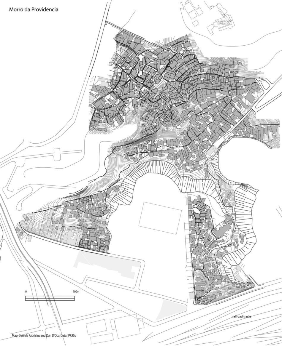
Providência—Rio’s Oldest Favela
At 110 years old, Morro da Providência is considered the first favela in Rio. It is also where the name favela originated. When part of the hill was occupied in the 19th century, it was named the Morro da Favela; the name was supposedly derived from the favela bush native to northeast Brazil. Providência was not used until the 1920s and ’30s. The first occupants of the hill were soldiers returning from the Canudos War in 1897, a military campaign waged in the northeast against the religious sect of Antonio Conselheiro. These soldiers were given permission to temporarily settle on the empty hilltop, with its precariously steep sides, in the historical center of Rio, an area where the urban fabric is violently interrupted by steep hilltops. Most of these had once served as natural vantage points for fortresses that for centuries made this port one of the world’s best-guarded.
While Providência is the oldest surviving favela, it was not the only one in the late 19th century—other hillsides were also settled, especially after the removal of working-class housing from the city center. Providência had 100 houses by 1904, and 1,500 by 1933. The population today is around 5,000, an only moderate increase over a seventy-year period.12 Like many favelas that develop near transportation hubs, Providência is adjacent to Rio’s main train station, built circa 1858. In Rio one can trace a line of favelas along the rail line all the way to the edge of the city, with the oldest ones closer to Central do Brasil station. Providência was once close to the port and the water, but after decades of landfill it has found itself farther inland. It is now surrounded by hospitals, factories, shipping and port areas, bus depots, and historic government and military stations that form its decidedly non-residential surroundings.
It is this area in Rio that is perhaps most exemplary of the combination of port and fort that is the city’s founding typology and the source of the topographic apartheid that has come to be associated with a specifically Cariocaian version of the favela.13 As an island floating within one of the oldest and most highly-planned sections of the city, Providência came to define what would be the qualities of the quintessential Rio favela—embedded yet isolated, close yet far, integrated yet segregated. The houses range from wooden structures dating to the original occupation to concrete and stucco buildings. The community includes a church built by the Canudos soldiers and, at one end, a set of stone steps that date from the 17th century and are said to have been built by slaves. It is these historic artifacts that have prompted what may be the first project of its kind: The city government, as part of its program of revitalizing the downtown port, has been working on building a museum in the favela or, to be more exact, turning the morro itself into an open-air museum. The program proposes returning several houses to their 19th-century state, complete with a re-creation of their contents and an illumination scheme that would light the whole community at night. This Disney-esque proposal, while recognizing the community’s historical and cultural legacy, runs the risk of turning not simply Providência’s past but also its current residents into objects of exhibition. Moreover, the “historic preservation” of the considerable hardships experienced by the community’s first residents could be misinterpreted as a romanticization of the poverty many residents face today.
The problems that affect favelas in parts of the city far from the center also affect residents here. In 2005, this relatively peaceful favela, a frequent site for visiting architecture students and social workers, became one of the centers of a brutal war between the military police and rival drug gangs. Morro da Providência was one of the favelas most affected by the government raids and was occupied by military police for several days of constant gun battles. These events prompted outrage in the international press for the out-of-proportion response to the security threat posed by the gang rivalry.
Currents of Informality
Street peddlers take over the streets, favelas fill the space between highways, groups of the homeless install themselves under viaducts. Like some amorphous tide, they spread everywhere, taking over the interstitial spaces.
— Nelson Brissac, Paisagens Urbanas
While the favela is the stable icon of informality and of poverty, the less visible networks, relationships, economies, and social practices that take place outside favelas are just as pregnant with informal forces and protocols. This plays itself out in the realms of work and the economy, in street markets, the selling of pirated goods, the distribution of drugs throughout the city using anything from taxis to garbage-truck drivers, the playing of illegal lotteries, and other practices that occupy the terrain between the licit and the illicit. It plays itself out in the small favors and bribes used to facilitate bureaucratic processes, in the corruption on the level of the political and juridical, in the proliferation of privatized and sometimes illegal services and systems that make the city work but that fall outside the realm of regulation. These make not only Rio but also most cities in the world work. A spatial representation of these practices is difficult if not impossible. They are not contained by the boundaries of islands and enclaves, nor do they appear in satellite imagery. If favelas are islands and the city is the sea, then that sea is filled with currents, routes, tides . . . and pirates.
The counterimage to a city of fractured and enclaved spaces is that of a continuous urban mass. Here the “mass” can be understood as it has been historically—as a volume of bodies with a political will awaiting a form through which to express it—or alternatively an urban mass in the material sense, a physical continuity with energy and potential but no predefined or final form. Cities are never only enclaves or separate territories. In Rio, a city is also the physical spaces in between, the forces of informality that never take an absolute form but always fall into a greater spectrum of protocols. Informality is a survival strategy and, as such, is also a way of evading or manipulating power. Discourse on informality is often contradictory because it describes both the “problem”—the effects of the benign neglect characteristic of economic liberalism—and the “solution”—the strategies of political and social agency within that framework.
Gatos
Gatos, literally “cats,” is Rio’s term for the unofficial and often illegal connections made to legal sources of water and electricity in favelas and other areas. Gatos, if understood as emblematic of the relationship between the formal and the informal, would represent the point of transition from a controlled and regulated network to an “invisible” and undocumented complex. One gato could potentially be the starting point from which an entire community would thrive. A gato is not a leak in the system so much as a planned assault on it.
Control over urban space is exercised not only through the ownership of property but also through the monopolization infrastructures. These include physical networks like water, sewage, electricity, and telephone, and what flows through them. These networks, often even more than the physical spaces of architecture, form the vital system that holds the city together and are perhaps its most valuable asset. In Brazil, as in many countries, control of this monopoly has swung widely between private foreign investors and state agencies. One example is Grupo Light, Rio’s first electric utility company, started in 1907 by a Canadian firm. It was eventually controlled by the government from the 1940s through the military regime, only to be privatized in 1996 and sold back to French and Canadian firms. Today the price per kilowatt for electricity in Rio is comparable to that in New York City, while the average income is many times lower, this partially explains why electricity is so often pirated. Nevertheless, only 15% of the city’s residents (at least, according to Grupo Light) use pirated electricity.14
Gatos are not constructed simply out of economic need. In many cases, the necessary infrastructures simply do not exist in newly occupied spaces. Gatos are technically illegal and often unreliable, but receiving services from an agency for a residence that is quasi or wholly illegal is sometimes impossible or just very slow. If formal utility accounts are established, it is after citizens have already provided themselves with service, or in favelas that are already largely urbanized. Gatos usually refer to electrical networks, but there are “gatos” for water, gas, sewage, telephone, cable TV, and even public roads. Streets and highways are often prime territory for roadside invasions and are extended or barricaded by favela residents according to their needs. In the far periphery, roads are sometimes illegally constructed to service an informal subdivision to come.
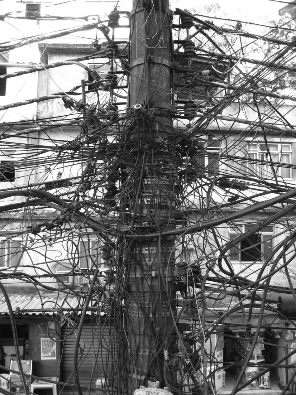
The infrastructural connections in a favela are highly visible, unlike those in the formal city, where plumbing and other utilities are embedded in streets and architecture. While Rio has had electricity for as long as most European cities, favelas, which are now about 98% electrified, were not connected to the city’s major utilities even twenty years ago.15 While perhaps no more haphazard than the tangles of wires and tubes that run through the walls of any building, the lines that zigzag through a favela are remarkable in both their complexity and their fragility. Electrical wires and thin plastic tubes carrying fresh water drape over buildings, run along paths and stairs and up walls, bundling and splintering in often dangerous configurations, as when electrical wires are used to support water pipes. In some instances, electricity poles are co-opted and used as support pillars for houses. Most poles are heavy with hundreds of power lines.
Power companies and public officials try to put a stop not only to the piracy but also to the level of consumption overtaxing the system. Fluctuations in the value of the currency, predatory credit systems, and the black market have made electrical commodities like televisions, microwaves, and air conditioners the norm as opposed to the exception in favela households. The result is a significant level of dependence on these gatos. Fresh water, on the other hand, is taken from both city sources and the abundant natural sources available in Rio. Many favelas form near water sources (like canals, springs, lagoons, and rivers), determining location perhaps as much as access to transportation. While fresh and relatively safe water is often available, sewage and waste-removal systems are more difficult to set up. Gatos, it seems, are more effective for tapping an incoming flow than for creating an outgoing one.
A ubiquitous presence in the favela is the satellite dish. Satellite and cable TV is abundant in favelas, though cable companies have not wired these areas, knowing that most residents cannot afford the monthly costs, which can be one-third of the average monthly salary. Instead, local entrepreneurs make a business of hooking up cable and satellite televisions, charging a comparatively modest fee for their “subscribers.” There are organized consortia of informal cable TV providers in favelas, at times run by militias, with as many as 10,000 subscribers.16
Infrastructures like electricity and plumbing were historically used by cities to establish their modernity. Circulation, through whatever network, is seen as a marker of the success of a city’s connectivity not only within its borders but also to other cities and distribution networks. The image of circulation, whether it is of sewage or broadband, proposes an organic unity that is both machine- and body-like and is considered crucial to productivity in a capitalist city. The gato is both an extension of that system and a disruption of its fluidity. Through the colonization of its flows, the gato expands the network of the formal city into ever finer networks, invisibly growing to accommodate populations that can no longer be accounted for. While communications and power companies have commodified these networks into individual parcels and accounts, favela residents treat them almost like natural resources, flows that can be extended ad infinitum. While there is some communal planning of these connections, it is for the most part a process that takes place one house at a time. In cities where one’s rootedness and even citizenship is defined not only by an address but also by one’s utility bills, account numbers, and listing in a phone book, being connected by gatos creates vast populations that are by official standards undefined and unaccounted for, but in truth already intensely linked with the city.
Vans
Van is Brazilian slang for the small passenger vans that provides a system of informal transportation in Rio. Such transportation has existed in the city since the postwar period, when abandoned or stolen busses were illegally used to make up for the shortcomings of the official system. These were particularly effective in response to the needs of the growing urban population. The vans that have appeared since the beginning of the 1990s, however, reflect a new demand. These vans typically travel farther—sixty to eighty kilometers on average—and carry only around eight passengers. For the half of the urban population that lives in peripheral areas, these vans provide the fastest and often the only way to reach the city centers. Almost all the riders use the vans for commuting to work, and most of these riders are employed in the service sector. Because of their small size, vans are able to reach more remote areas or the narrower streets in favelas, producing a broader, thinner, and more diverse transportation network. This network could be thought of as a diagram reflecting the true complexity of Rio’s urban form.17
The van drivers typically operate in associations that compete with one another for territory. The driver may be the owner of the van (often purchased through a bank loan) or may be hired by the owner of a fleet. The average vehicle is only three years old and is air-conditioned, making its service superior to that of the city buses. A van driver earns around three times as much as the bus drivers employed by the city but without the security or benefits offered by formal employment. Van drivers usually use cell phones to communicate with a main dispatcher, who guides them through the perils of traffic or police checkpoints. Most services have organized routes based on demand, with regular pick-up and drop-off points and few stops in between.18
When the paratransit vans first appeared in the early 1990s, around 600 were in operation. Now the number has risen to about 10,000 (in contrast to the city’s bus fleet of 7,366), with 600,000 riders per day. The expansion of the city into peripheral areas, the informalization of the labor market, and the rise of the service sector have made the vans an irreplaceable part of the city’s daily flow. Riding a van carries a stigma, since many passengers live in marginalized neighborhoods, though ironically van rides can cost up to three times as much as public bus rides. Similar vans, though not nearly as prevalent, provide exclusive services for residents of condominiums and gated communities, for tourists, and for schoolchildren, and form a fragmented infrastructure of isolated itineraries. The shared space of public transportation becomes inhabited by fewer and fewer.19
The rise of vans in the city is also connected to the global auto industry. The availability of the vans on the Brazilian auto market coincided with changes in trade regulations that facilitated their import. While Brazil’s national production of passenger buses has fallen by 50%, auto manufacturers producing the vans are enjoying a surge in profits, and many even encourage the informal transportation economy in their advertisements.20
Government officials call the unregulated vans, which compete with public transportation, a “cancer” and warn of the “Mexicanization” of the system (Mexico City, along with Lima, Bogotá and other cities, has virtually lost its public transportation systems due to informal transport). In Rio, van drivers are forbidden to use the same routes as those of public buses but nevertheless shadow the buses along major routes and poach extra passengers who are waiting at very crowded bus stops. Rio’s government has estimated that it loses around $43 million Reais per year in fares. In one neighborhood, Cachoeiras de Macau, the public bus system has ceased to operate because of low ridership. Showing its community solidarity (and power), the local van service provides free transport for students and the elderly, who once took the public bus for free. The city also recently admitted that it did not have the resources to bus Rio’s children to public schools and that it knew many children use the vans. The suburban train network, which connects many of the peripheral areas with the city center, has lost an astonishing half of its riders since the 1980s (even though the peripheral population rose), causing some stations to be shut down. Rio’s efficient but inadequately sized subway system still carries only a very small percentage of riders and covers only a small portion of the city.21
Almost every city in Brazil has some form of illegal transit, from vans to full-size buses to motorcycles driven by boys. The level of tolerance of these ranges widely from legal integration into the formal system to strictly enforced counterlegislation. But even where laws are enforced, an element of informality and illegality remains. If documents are required, they can be falsified. When vans are stopped and fined, bribes can be paid. This lucrative and illegal enterprise is in some places run by a “van mafia” that operates large fleets and document-counterfeiting businesses. Rio’s most powerful van mafia was recently under investigation for the assassination of the head of the city’s transit authority.22
An Informal Geography
Rio is without question a divided city, a cidade partida, as Brazilian journalist Zuenir Ventura describes it, but its organization is not the result of planning. According to the tenets of the Athens Charter penned by CIAM in 1943 (of which Brasília remains one of the few built artifacts), a city should be, like a body, divided into functions. Living, work, leisure, and circulation are relegated to different urban sectors requiring specialized urban typologies. In the late 1950s, the group that would later become Team 10—Alison and Peter Smithson, Aldo van Eyck, and others—had proposed a model of organization based on relationships of living and community. The city, rather than being divided by function, would be organized by the scales of social identity created by the house, the street, the neighborhood, and the city. Contemporary cities like Rio are, however, divided according to different parameters. The relinquishing of planning functions by many governments and the new forms of connectivity allowed by communications technologies have produced a geography characterized by decentralization and horizontality; by uncommitted organization without hierarchy; by an entropic field of nonlinear and chaotic effects; and by enclaves of both global capital and local poverty. The spaces of this process have been described over the last thirty years as having formed a post-industrial city, a networked city, or a postmodern city.
This is the geography in which informality has emerged, beyond modernity’s peripheral vision. Informal housing and markets have found a basic grid of support in the architectural ruins of incomplete or abandoned projects of modernization, whether in Modernist housing projects designed to Athens Charter specifications, infrastructural objects and large buildings that have fallen into disuse, or what remains of social services like schools and hospitals, built in more optimistic times. These housing projects, highway overpasses, warehouses, and even high-rises are modified, mutated, adapted, and inhabited. Even if favelas form a close symbiosis with late-capitalist cities, they are not restricted to one urban typology. Premodern and colonial cities, modern cities, and postmodern cities can accommodate the favela’s flexible typology. This is one reason it is difficult to situate favelas historically. On the one hand, they are very much a product of modernity, and particularly of the unprecedented scale of urbanization happening all over the globe. Favelas are not the product of “primitive” or premodern societies, like many of the urban typologies studied by Team 10 members in the 1960s, but are instead specifically related to industrialization and modernization. On the other hand, they bear no ideology of progress or marks of newness.
Even though they are very much a product of modern economies and social formations, favelas are still associated with an abject, primitive, or regressive form of urban life. Even if Rio’s favelas were once visited and celebrated by figures like Le Corbusier and Marinetti, they remained an image of counter-modernity, particularly in a country like Brazil, which developed a strong Modernist ethos. Favelas are frequently misunderstood as a transitional urbanism, a phase of the urban form as it evolves from a premodern to a modern civilization. The slums that appeared in European cities in the 19th century and gave way to today’s modern metropolises are often used as examples to argue this point. But there is no evidence or reason to believe that the informal settlements in the Third World will or should develop as European cities do. Brazilian favelas are over 100 years old and don’t necessarily become more urbanized with time; sometimes, in fact, “favelization,” a planned and newly constructed portion of the city eventually (sometimes in just a few years) becomes a favela. As Mike Davis has pointed out, the population living in urban slums is that of the entire world in 1844, when Friedrich Engels documented the conditions of Manchester.23 It would be absurd and impossible to apply such a specifically European and historical model to what is now a diverse global condition.
Cities like Rio de Janeiro and, perhaps more urgently, cities like Lima, which are more than half informal, must be represented in new ways. Informality requires a rethinking of mapping, both of informal areas and of the city as a whole. The invisibility of the informal sets it apart from other modes of urban life and produces a different and problematic relationship to representation. Since it evades “the bureaucratic gaze,” it also has forms of citizenship that fall by the wayside but that must be recuperated in some way. The geography of informality—its enclaves and networks or islands and currents—presents barriers to political representation and social inclusion. But in the many ways in which the favela and the informal exceed the boundaries and borders that seem to contain them, they also present the potential for forms of community solidarity and the claiming of the “right to the city.”
Informal settlements are changing the nature of cities. Now accounting for one third of urban habitation,24 they are the new paradigm of urbanism. The informal settlement must be understood alongside other urban and housing typologies—apartment block, suburb, gated community, garden city, skyscraper, tower in the park, historic center, casbah, square, and medieval city. In response to this “new paradigm of human settlements,”25 should there be new paradigms of housing, of urban planning, of political representation, of infrastructure, of economy, of social services, and of culture?
The need for the development of conceptual paradigms is emphasized by urbanist Nezar Al Sayyad, who has described the shift in the 20th-century study of cities as it moved from the Chicago School to the Los Angeles School.26 According to Al Sayyad, in the Chicago School the city is studied from what is essentially a Modernist perspective based on the model of a centralized nucleus with clear distinctions between center and periphery. The city is a place with discernible urban characteristics, made up of an ecology of individuals who progress from traditional to modern cultures. The Los Angeles model, which can be characterized as postmodern, developed in the late 1970s as an argument suggesting that Los Angeles is not an urban anomaly but in fact a new type. This school emphasized the decentralization of the city and the role of the global capitalist economy and advances in communications technology in determining urban form. The periphery of the city, in this case, controls the center. What Al Sayyad argues is that these two models, exported and applied to cities in the Third World, no longer apply (or perhaps never did) to most cities in the world, and that the very tools of analysis must be reconsidered: “The urban future does not lie in Chicago or L.A., and it will not be shaped according to the schools of thought named after them. Rather, the future lies in cities like Cairo, Rio de Janeiro, Istanbul, and Bombay, and can best be investigated by looking at them. . . . Urban informality, as situated in many Third World cities, may be emerging as a new paradigm for understanding urban culture.”27 The problem described is in fact twofold: First, Western (in this case exclusively North American) paradigms are being applied to other parts of the world, a tendency that has existed since the establishment and planning of colonial cities. Second, the Los Angeles model may simply be inadequate for understanding cities at a point at least thirty years after it was declared postmodern.
The informal city contains the logic of these two previous models. The Modernist city still exists but as a ruin, its institutions, divisions, infrastructures, and sectors crumbling but still inhabited and used, albeit in different or improvised ways. The postmodern city and its speculative land use, its wide swaths of abandoned land, its glittering towers and derelict sites, its harsh adjacencies and scaleless networks of communication, also exist. Furthermore, the neat separation of these two models is not entirely possible where qualities of both coexist and have historically overlapped.
The third element, excluded from both models, is the urbanity that takes place in between the ruins of the Modernist city and the entropic expanses of the postmodern city. It lies just outside of the “networked society,” falling under its radar. But it is, of course, tied into it in many ways. This new urbanity is one of tremendous growth, ongoing horizontal density, intense proximity and activity, communities that form with a logic that somehow can be applied at both micro and macro scales, nebulous legalities, constant metamorphosis, warring factions, economic micro-activity, and infrastructures that are fractured, incomplete, and often self-formed. The Modernist dichotomies of rural/urban, traditional/modern, industrial/agricultural, religious/secular, and local/global, which long ago began to lose their footing, have been pushed into even more extreme contortions by informality. Similarly, terms like decentralization, networks, peripheral, sprawl, and post-industrial, which largely characterize postmodern analyses of the city, are mostly applicable but far from adequate in describing urban qualities that exceed or even precede these concepts. What is the status of these relationships today, and how can they be studied? And is the informal city perhaps a model that describes not only Third World conditions but also many aspects of First World cities?
The contradictory geographies of favelas suggest that the challenge may lie in positively defining qualities of the informal without falling into a simple dialectic with the formal and in turn employing a radical notion of modernity that includes the informal.28 The term informal is usually relegated to economic and sociological descriptions of cities. What is often overlooked is that the informal is also a cultural and conceptual topos, not just in the Third World, but in every city. While representations of informality are possible, they are also unstable. Perhaps, like the notion of the formlessness once described by Georges Bataille, informality “resists epistemic capture.”29 Denis Hollier cites as an example the Platonic dialogue in which the category of objects including mud, hair, and dirt are evoked as a challenge to a stable and closed notion of form.30 This repressed and forbidden category of matter, like the repressed category of urban informality, is one of structures that, like cities, do not have stable or knowable forms.
The challenge may be to understand that cities are for the most part always informal and exceed representation. Yves-Alain Bois describes formlessness not as a concept but as an “anti-concept”: “Were you to define it as a concept, it would be the concept of undermining concepts, of depriving them of their boundaries, their capacity to articulate the world.”31 As geographers, architects, or planners, accepting our inability to articulate urban boundaries is infinitely useful for describing the contemporary city. Accepting partial knowledge and relinquishing epistemic control is a step toward a geography of the informal.