The Transfrontier Metropolis
A precedent for binational land use planning lies some eight thousand miles away, in Western Europe. Nearly two decades ago, some European nations recognized the need for cross-border planning. Working within one of the European Community’s parliamentary bodies—the Council of Europe—leaders from various countries created binational agreements for environmental, transportation, and regional planning along the boundaries of The Netherlands, Belgium, France, Germany, Italy, and Switzerland. Because these agreements transferred local planning authority to the realm of European Community politics, participating nations began to refer to border region planning as “small foreign policy.”
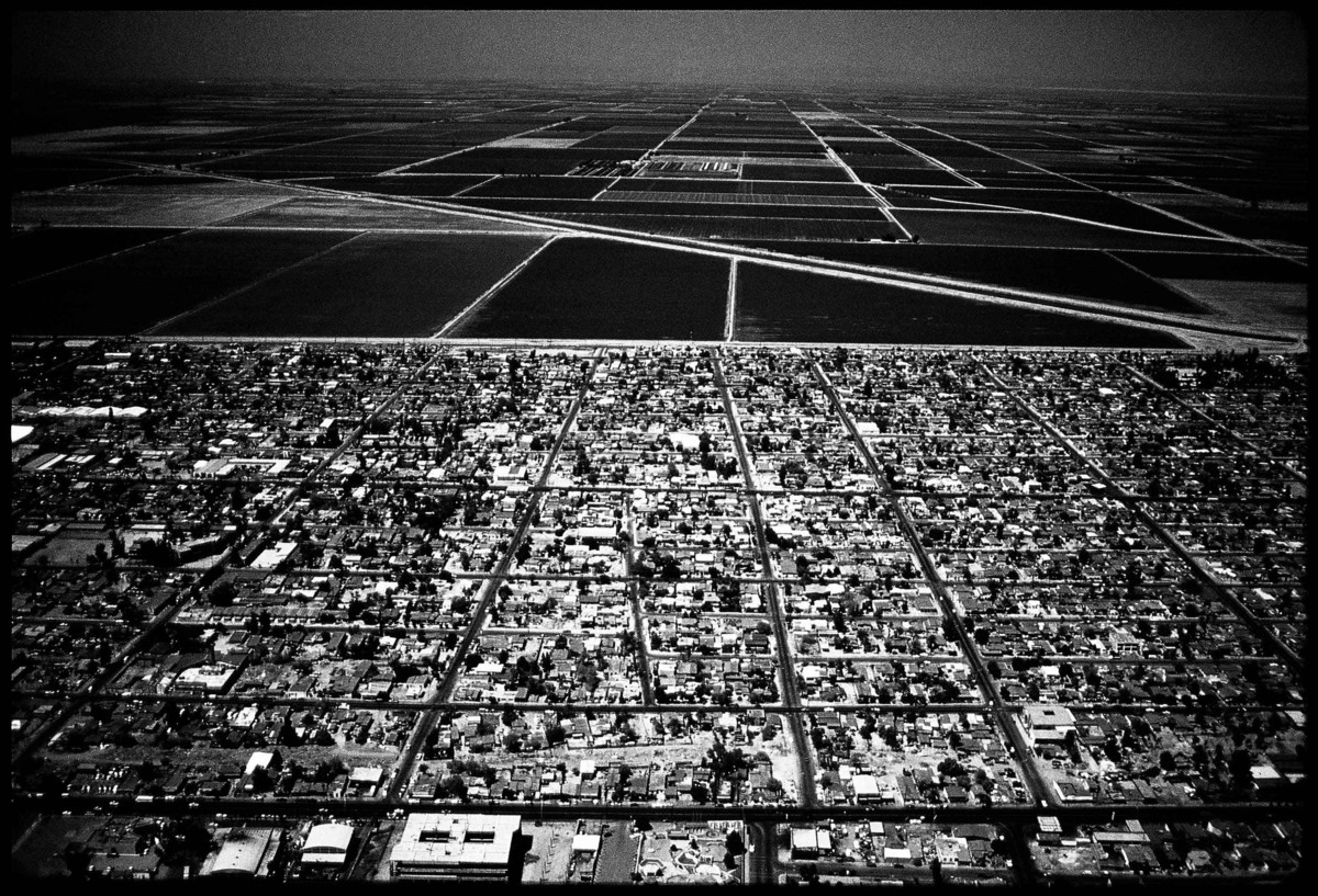
Such small foreign policies should be the objectives of future global planning mechanisms in transfrontier regions such as Tijuana-San Diego. As we look at the region’s landscape, several design and land use planning questions arise. For instance, Tijuana’s border population density is high—the city seems crowded up against the frontier. Flat, developable land is scarce, and mountains and unstable canyons limit growth; also, there is a shortage of housing. In contrast, San Diego is a freewheeling, sprawling city whose growth tends to thrust north and east, rather than south; at its southern (international) boundary lie vast tracts of vacant land. The growth patterns of the two cities must be balanced within this regional context.
An interesting project for planners concerns the design of the land adjacent to the international boundary. For example, there has never been a truly comprehensive urban design plan for the San Ysidro international border crossing. This crossing, the largest in North America, contains a chaotic juxtaposition of warehouses, parking lots, factories, retail stores, an immigration detention facility, freeways, residential neighborhoods, commercial strips and commercial centers, open spaces for wetlands and flood control, and privately owned farms. A key challenge will be to create a plan that allows for circulation and economic development but does not compromise the work of immigration control and ýurveillance of smugglers. For the international customs and border patrol community, large populations and high urban densities represent potential obstacles to efficient law enforcement. Good design strategies will help to resolve this and other transfrontier dilemmas.
The transfrontier metropolis is emerging as a new type of urbanism, wherein city/regions become bridges between national cultures, spaces from which to launch the global activities of common markets or trade blocs. Transnational urban planning, however, is not without obstacles. The Mexico-United States border epitomizes one critical condition of late-20th-century urbanism. Notwithstanding the cross-border synergies discussed here, the transfrontier metropolitan landscape is characterized now by social polarities. On the Mexican side, as many as half of all housing units are part of shantytowns, with structures of scrap wood, tin roofs, recycled tires, and concrete block; these colonias lie amid vast, dusty, treeless plains or in flood-prone canyons devoid of paved streets, street lighting, parks, piped water, and sewerage infrastructure. North of the border, in contrast, more than half of urban dwellers live in the lap of American suburban luxury, in middle- and upper-middle-class single-family houses surrounded by large lawns and shade trees, and, further out, by modern freeways, decent schools, and well-stocked shopping centers.
The fusion of divergent styles of urbanism—one Iberian and Meso-American, the other Anglo-European—into a unified city/region remains a work-in-progress. The national boundaries that divide these regions can at times be places of great political tension. Immigration and drug smuggling characterize our global era, and they can make the border as explosive as a 19th-century warzone. Anti-immigration factions in the U.S. advocate building walls, erecting fences, and digging ditches, but as we move into the 21st century such measures will surely prove to be the antithesis of the kind of intrastructure needed for the building of transfrontier urban communities.
Label
A New Kind of International City
If the 20th century has been the era of the modernist and postmodernist city, the 21st century will likely be the age of the “global city.” In the new millennium, urban places will respond to more than national political, economic, and social forces. Given the rise of transnational banking, off-shore manufacturing, multination trade blocs, global communications, and the international division of labor, cities will be profoundly enmeshed in a network of world systems.
The “internationalization” of urban space has been taking shape throughout this century. For example, “International Style” architecture was introduced in the United States in the 1930s, the result of a collaboration among an emerging global network of designers who shared a common vision about how technology would determine the design of the city. Thus began the “transnationalization” of architecture.
Today we must confront not only the internationalization of architectural and design practices, but the globalization of urban space itself. No longer simply an artifact upon which designers from different corners of the globe practice their profession, the city has become a container increasingly shaped and transformed by such international actors as corporate investors, transnational financial interests, transborder common markets, and cross-national governmental organizations. To accommodate the forces of globalization, the city has been forced to reinvent itself; sprawling “edge cities” and dense, high-tech corporate business districts are just two recent responses to the globalization of the metropolis.
One possible prototype of global urban space in the next century is what I have termed the “transfrontier metropolis.” Since the rise of the nation-state in the 19th century, cities have been understood as physical places lying within the boundaries of a sovereign nation. Yet now we find city regions that sprawl across international boundaries, notably in Western Europe and North America. Important European transfrontier urban agglomerations, with populations ranging between 300,000 and one million inhabitants, include Basel-Mulhouse-Freiburg (Swiss-French-German border), Maastricht-Aachen-Liege (Dutch-German-Belgian border), metropolitan Geneva (Swiss-French border), and metropolitan Strasbourg (French-German border). In North America, one finds transfrontier urban regions of between 250,000 and four million people along the Canada-U.S. border at Vancouver-Victoria-Seattle, Detroit-Windsor, and Toronto-Hamilton-Buffalo, and on the Mexico-U.S. border at Tijuana-San Diego, Ciudad Juarez-El Paso, Mexicali-Calexico/El Centro, Nuevo Laredo-Laredo, Reynosa-McAllen, and Matamoros-Brownsville.
Transfrontier metropolitan regions typically consist of two or more settlement centers located around an international boundary. Over time these settlements have fused to form a single ecological and functional city/region. Why has this occurred? Briefly, the building of cities over the last two centuries has been controlled and managed by nation-states. Territorial politics in the 19th and early 20th centuries dictated that nations guard their borders. This “shelter” mentality fostered a common pattern of settlement in which the largest urban concentrations tended to be located away from the physical edges of a nation. Before 1950, in fact, boundary regions were viewed as buffer zones that helped to protect the nation from invasion by land. Under these conditions, there were few significant cities near national boundaries. A glance at the map of Western Europe corroborates this: Paris, Madrid, Rome, Vienna, and Frankfurt all lie in the interior of their respective countries. Across the Atlantic in the Americas, we see a similar pattern: Mexico City, Lima, São Paulo, and Santiago are all a considerable distance from the nearest international boundary.
Only in the second half of this century has border territory become prime real estate for settlement and city building. The age of land warfare is past. Global markets and free trade are the new dominant realities, and property at the edges of nations is attracting investors, businesses, and governments. Industrial parks, highways, rail systems, and airports that once bypassed international frontiers are relocating there. It is now possible—and someday perhaps will be preferable—for large cities to be developed along international frontiers.
Perhaps the most vivid example of transfrontier urban space is found along the border between Mexico and the United States. More than ten million people live in the transfrontier metropolitan regions that at intervals straddle the two-thousand-mile border between Matamoros-Brownsville and Tijuana-San Diego. Citizens on both sides of the boundary are increasingly drawn together into a web of north-south relations, in which the dichotomies of “Third World/First World” and “developing/developed” are cast aside as urban neighbors share common transnational living and working spaces. The largest Mexico-U.S. transfrontier urbanized regions include Tijuana-San Diego (estimated population, 4.5 million), Ciudad Juarez-El Paso (2.5 million), Mexicali-Calexico (2.0 million), Reynosa-McAllen (0.8 million), Matamoros-Brownsville (0.7 million), and Nuevo Laredo-Laredo (0.5 million). The forces that draw neighbors from two different cultures into a transfrontier city structure include:
International Commuters
Nearly 300,000 workers legally travel across the border, usually from Mexico to the U.S., to work on a daily or weekly basis. Countless thousands of others cross illegally with a border resident card (which permits Mexican residents to cross into the U.S. for nonwork purposes, but which is often used illegally to get to work). The creation of a group of legal international commuters within the transfrontier urban region can be traced to a 1963 U.S. Supreme Court decision (Texas State AFL-CIO v. Kennedy) which ruled that anyone possessing an alien resident card (allowing permanent residence) could live outside the borders as long as they continued to work within the U.S. In effect, the Court recognized that border cities could serve as “bedroom communities” for legal immigrants.
Transfrontier Consumers
Commercial transactions amounting to more than six billion dollars occur annually across the Mexico-U.S. border, while several hundred million border crossings take place each year, primarily between the partners that form the various transnational city regions. This is unquestionably the most populous and active border region in the world. Consumers constitute the largest group of legal border crossers, and are perhaps the primary group linking the Mexico-U.S. transfrontier metropolis; the North American Free Trade Agreement (NAFTA), which emphasizes opening borders and increasing economic integration, will only heighten the unification of such settlements. Indeed, consumers create a complex web of flows north and south across the border, whose circulation patterns can be predicted based on comparative advantages of products on either side of the frontier: U.S. consumers travel south to purchase prescription drugs, bottled beverages, furniture, foods, arts and crafts, medical and dental services, car repairs, and entertainment; Mexican consumers travel north for manufactured goods such as clothing, electronic products, refrigerators, washing machines, automobiles, auto parts, etc.
Transborder Tourism
Since the 1920s, Mexican border cities have defined themselves partly as recreational places for U.S. border region residents and visitors. In the 1920s, prohibition of alcohol and gambling in the United States catalyzed a new Mexican industry—border tourism. By the second half of the twenties, the infrastructure of tourism had come to define the architecture of Mexican border towns. So too, the landscape of Mexican border cities began to be transformed to attract American visitors. And this legacy endures; tourism continues to generate vital revenue in the border region, and it is the third largest source of national income for the whole of Mexico after oil and manufacturing.
Global Factories
Much has been written about “off-shore” manufacturing, by which multinational corporations seeking to reduce labor costs relocate their assembly work to places like Hong Kong, Singapore, South Korea, Taiwan, and Haiti. Since 1965 Mexico has been an important participant in this globalization of the factory, and most of the nation’s global factories are in the transfrontier cities. Typically, a cheap labor enclave—amaquiladora—is linked to a headquarters office and warehouse in the U.S, creating within the transfrontier metropolis a “twin plant” system of U.S. investors/managers and Mexican assemblers. These global factories are very profitable for both countries. Mexicans charge dollarized rents and gain wages for a growing number of industrial workers (some three-quarter million at last count), while U.S. (and other foreign) companies save millions of dollars in labor costs. This sector brings an estimated three billion dollars of annual income to Mexico.
Transnational Housing and Land Markets
Urban dwellers in the transfrontier urban regions consume not only goods and services on both sides of the boundary, but housing and land as well. NAFTA is spurring the purchase/lease of land by global investors along the border, particularly in Baja California, where there are now many plans for international resorts, commercial developments, and luxury housing. Baja California already has the second largest enclave of expatriate American homeowners (the largest is in the Guadalajara region), with some 15,000–20,000 Americans living along the Baja coast. Meanwhile, increasing numbers of Mexican immigrants, with legal work and immigration status, are buying homes in the U.S. Some members of a family may live in the U.S., while others remain in Mexico. The hard edge of political demarcation—the physical boundary—thus begins to blur, and the transfrontier region becomes the true urban life space of the border dweller, a more precise spatial construct for defining the experience of binational urban families.
Transfrontier Architecture
The growth of a global economy and the emergence of transfrontier cities like Tijuana-San Diego have created a unique landscape on the Mexico-U.S. border. As one travels along the Mexican border, evidence of U.S. influence on the landscape abounds. How else to explain the Tudor houses in an upper-class neighborhood of Tijuana, or the suburban tract houses and condominiums, the U.S.-style shopping malls and fast food outlets sprouting everywhere? In the poor neighborhoods—the squatter communities or colonias—the recycling of materials purchased in the U.S., such as rubber tires, used lumber, and metal highways signs, is an important element of the vernacular architecture. North of the border, Mexican influence takes two forms. First is the revival of various styles of architecture such as Mission, Spanish Colonial, and so forth; red tile roofs and adobe-like stucco walls are common evidence of Mexican influence. But even more significant may be the landscape created by Mexican migrants in their barrios; here we find ornate fences and religious yardscapes, colorful murals and graffiti, decorated storefronts and elaborate street vendor marketing props—a rich array of imagery to incorporate into the design of transfrontier border cities in the next century.
One of the greatest challenge for architects and planners in the next century will be to adjust their practices to new global spaces like the Mexico-U.S. transfrontier metropolis. The Tijuana-San Diego metropolitan area—hundreds of square miles of settlement and about four and a half million inhabitants—is the largest transfrontier metropolis in the world, and as such poses considerable challenges to city planners and designers. During the last two decades, in fact, professionals on both sides of the border have begun to recognize that, as the region grows, urban design must be managed on a transfrontier basis. Many public policy organizations, arms of local and state government, university research centers, and nongovernmental organizations have formed to create cross-border approaches to planning and design. Among the many issues that must be addressed transnationally are those of environmental management, transport infrastructure, and urban design/ land use planning.
Environmental Management
As early as the 1930s, Tijuana and San Diego realized that they shared a common ecology, mostly notably that of the watershed of a hydrological and drainage system. When Tijuana’s population boomed in the tourism-fueled expansion of the 1920s, the city’s sewerage infrastructure was so overstressed that sewage began to flow into the Tijuana River and across the border into the San Diego region. Three quarters of a century later, this ecological interdependence continues. Sewage spills from Tijuana to San Diego have plagued the region in this decade. Nearly five decades of separate control of the Tijuana and San Diego environmental systems must now be replaced by binational environmental management. The first steps in the process have been taken: U.S.-Mexican environmental agreements have been signed, allowing for greater local coordination of environmental controls. A binational sewage treatment facility, the first of its kind in North America, is under construction in southern San Diego county. Binational flood management and water reclamation projects are also being discussed.
Transport Infrastructure
A transfrontier metropolis, by definition, is a place where the circulation of people, goods, and services across the border must be facilitated so that the boundary does not jam the economic circuitry of the region. The region must be allowed to fulfill its destiny and become a city/region operating in the global economy. Thus, in Tijuana-San Diego, six hundred global factories must be able to function within the transfrontier metropolis. Billions of dollars in commercial transactions must be facilitated. Tens of thousands of workers, business persons, and students must cross the border daily and weekly. To make the region truly transnational, more sophisticated transportation infrastructure is needed, a fact recognized by regional policy makers who are now discussing a variety of improved transport facilities such as a new border crossing complex, a mass transit connection between downtown San Diego and downtown Tijuana, cross-border highway connections, regional port improvements, port-rail linkages, and a binational regional airport.
Urban Design/Land Use Planning
Better environmental and transport planning must be coordinated with the design and land use configuration of the transfrontier metropolis. Because Tijuana and San Diego were designed and planned separately throughout this century, their current land use patterns do not always align well across the border. Further, the land use planning processes of the two nations differ. In the U.S., local governments enjoy constitutionally based “police powers” over land use and zoning, while in Mexico, control over municipal decisions often lies with the state and federal governments. As a result, it is difficult to envision a workable transfrontier planning mechanism, especially since such a mechanism would require both nations to relinquish some control to a transfrontier authority.
Lawrence A. Herzog is professor of geography and Latin American studies at San Diego State University. His recent books include Where North Meets South, Changing Boundaries in the Americas, and the forthcoming From Aztec to High Tech.